

The LightLine: A bridge to somewhere?
After a decade of planning, iconic structure coming soon to Cedar Rapids

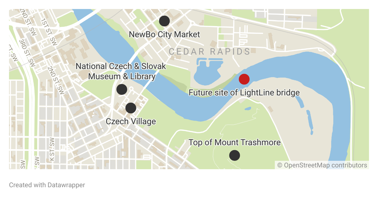
A ceremonial groundbreaking was held Tuesday for the Alliant Energy LightLine Pedestrian Bridge across the Cedar River in Cedar Rapids. The bridge, once projected to cost $11.3 million, instead will cost nearly $15 million.
The bridge is being promoted as connecting the Czech Village neighborhood on the southwest side of the river and New Bohemia on the northeast side. There’s just one problem: It doesn’t — at least, not their present versions.
The old Sinclair meatpacking plant and former housing tracts on the south side of the Cedar River are gone. One could argue that what this bridge does is enable pedestrians and bicyclists to go from the Cargill corn milling plant to the former Linn County landfill known as Mount Trashmore, which has a trail path to the top.
From a strictly utilitarian and geographic standpoint, I have to ask a stupid question: Why build this bridge?
The rails before the trails
In the mid- and late 19th century, railroads criss-crossed Iowa. Those nonexistent map dots that meteorologists still call out during severe weather once existed as stations or sidings. When rail lines began to be abandoned in the last quarter of the 20th century, their future was in flux. The Iowa Natural Heritage Foundation aided efforts to convert them into recreational trails.
The Cedar Valley Nature Trail runs from Evansdale to Boyson Road in Hiawatha. It was an early rails-to-trails project that opened Oct. 13, 1984, along the abandoned Waterloo, Cedar Falls & Northern interurban rail line.
A continuation of the trail network, the Cedar River Trail, runs all the way through Cedar Rapids. It enters downtown from Cedar Lake and follows the railroad corridor (where Fourth Street SE would be in the street grid), then Seventh Avenue SE. From there to the National Czech & Slovak Museum & Library, during construction of the Cedar River Flood Control System in 2022-24, a detour was sort of marked but trail users were mostly on their own. The trail has now been re-signed along the river and crosses it on 16th Avenue SW.
From the museum, the Cedar River Trail goes around Mount Trashmore. Then it runs near and occasionally on top of a railroad grade that was built in 1871 for the Burlington, Cedar Rapids and Minnesota Railway, which eventually was absorbed into the Chicago, Rock Island & Pacific Railroad, and abandoned when the Rock went bust in 1980. At the Johnson County line, it’s renamed the Hoover Nature Trail and recently has been paved all the way to Solon, where bicyclists can take either gravel roads or Iowa Highway 1 to Iowa City.
I give all that background to show that a good trail network has come to life bit by bit over the past 40 years. The Cedar Valley Nature Trail is an original part of “The Great American Rail-Trail,” which in its idealized form would run from Washington state to Washington, D.C.
Where the LightLine bridge fits in
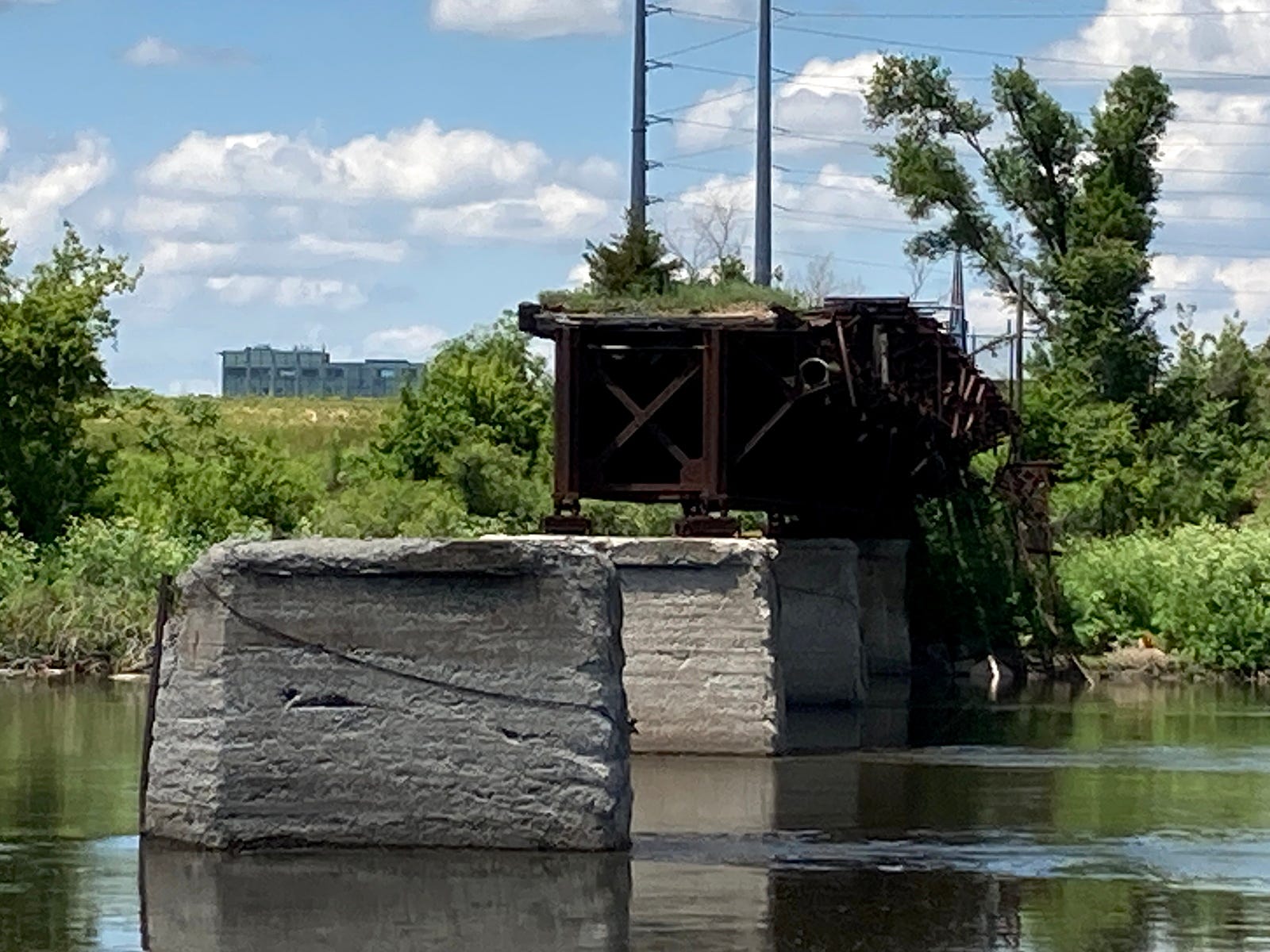
Websites for both the city of Cedar Rapids and ConnectCR, the group promoting development of the new bridge and Cedar Lake on the other side of downtown, date the first bridge at this location to 1865. Neither mentions its replacement in 1922, something covered by railroad bridge enthusiast/photographer John Marvig. It’s the 1922 bridge that was abandoned in 1980 and mostly destroyed in the Flood of 2008.
Steve Sovern, a member of ConnectCR’s board, has been thinking about a connection here for a decade. He wants it to be iconic, and a bridge tower designed to resemble the Sinclair meatpacking plant’s smokestack will do that. Alliant Energy has put $1 million toward the project and will light the bridge, hence the official name Alliant Energy LightLine. The bridge easily could have been named for Sovern otherwise, and I don’t want to rain on his parade. This is his baby — and the city of Cedar Rapids’ baby — and the baby of all the other donors and supporters.
What was left of the original bridge, which inspired Sovern’s idea, couldn’t be used, and two bridges across the Cedar River already serve trail users.
The 16th Avenue SW bridge, the “Bridge of Lions,” is a fine structure, has raised sidewalks on either side, and brings traffic right to the Czech Village clock tower and museum. There’s even a nice arch over the floodgate. On the north side of the museum, the 12th Avenue SE bridge just had a retrofit that turned it from a four-lane vehicle bridge to one vehicle lane and one bike lane in each direction.
If the LightLine bridge is to be the official Cedar River crossing in the American Discovery Trail and Great American Rail-Trail network, that means the main line will bypass Czech Village. Heading northward, trail users will leave the pungent fragrant area around Mount Trashmore, cross the new bridge, and follow the just-built concrete path on the north side of the river, missing Czech Village and the future LightLine Loop altogether.
I recognize that Czech Village is only a short hop away on one of the two bridges previously mentioned. Having an iconic bridge will be something for the glossy tourism/amenities guides. Having a pure pedestrian-bicycle bridge is nice. I might be overly annoyed at ConnectCR itself and every media outlet saying this bridge will connect two neighborhoods when geographically it is out of the way. I can see a rationale for connection in an abstract way. Maybe the “LightLine Loop” name could be extended to cover the circuit formed by the new bridge, Bridge of Lions, and riverside trails in between them.
If I had my pick of where to put a new bridge, I might have pointed farther downstream. A bridge near Winnebago Park on Old River Road SW could have connected with the Sac and Fox Trail, which goes to Indian Creek Nature Center. There are no other bridges there. The flaws in that idea, though, are the lack of a good connection to the Cedar River Trail, which is 1 mile west of this location and elevated on the railroad grade, and the Sac and Fox Trail’s lack of links to a wider network.
The LightLine bridge is projected to be completed in about two years. When finished, it will be a key feature in the views from the paths along the Cedar River and the top of Mount Trashmore, and maybe that’s all it needs to be welcomed.
My other work can be found on my website, Iowa Highway Ends, and its blog.
Iowa Writers Collaborative Roundup homepage and writer listing